
پرونده:Kuwait-Iraq barrier.png

اصلی پرونده (۱٬۰۶۰ × ۱٬۲۱۸ پـیـکـسهل, فـایـل گـأتـی: ۹۶۴ کیلوبایت, MIME مـونـد: image/png)
|
|
این پرونده ویکیتلمبار دله دَره. ونه دلهی بنویشتهئون (مازرونی) ره اینجه سِراق دنه. |
Transwiki approved by: w:en:User:Dmcdevit
This image was copied from wikipedia:en. The original description was:
Original map license (map from the CIA):
| This image is a work of a Central Intelligence Agency employee, taken or made as part of that person's official duties. As a Work of the United States Government, this image or media is in the public domain in the United States.
|

|
Source: Courtesy of the University of Texas Libraries, The University of Texas at Austin for the map originally found at : http://www.lib.utexas.edu/maps/middle_east_and_asia/kuwait_pol96.jpg
Modified map license (the one that can be seen here)
| من، دارنده حق تکثیر این اثر، این اثر را به مالکیت عمومی منتشر میکنم. این قابل اجرا در تمام نقاط جهان است. در برخی از کشورها ممکن است به صورت قانونی این امکانپذیر نباشد؛ اگر چنین است: من اجازهٔ استفاده از این اثر را برای هر مقصودی، بدون هیچگونه شرایطی میدهم، تا وقتی که این شرایط توسط قانون مستلزم نشده باشد. |
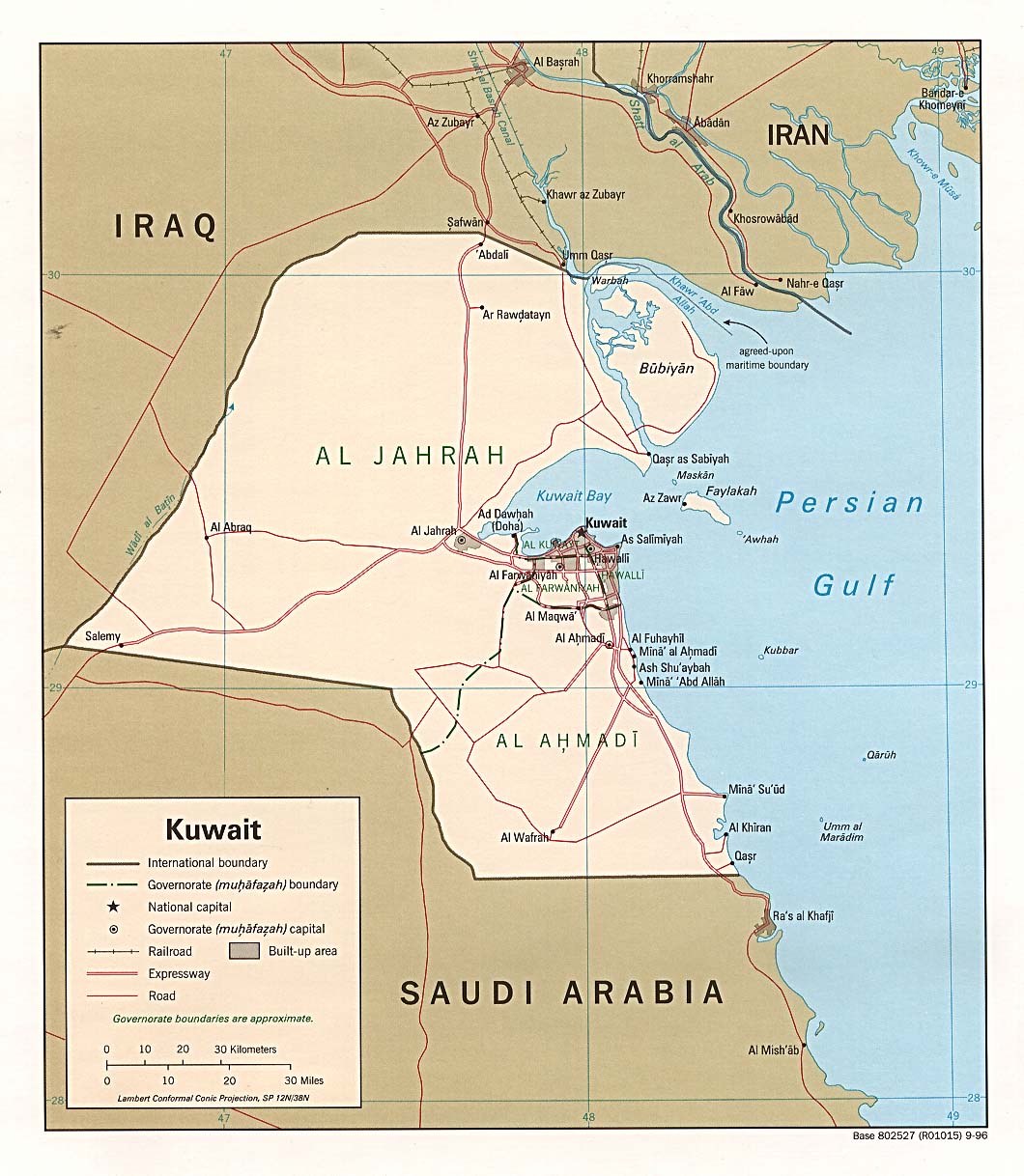
I drew the barrier on the map, based on the fact it extends 6 miles into Iraq and 3 into Kuwait.
Note
Even though this is a .png file the original file is .jpg, so the quality is fairly low.
.xcf version, can be opened in w:en:GIMP
سیاهه بارگذاری اصلی
| date/time | username | resolution | size | edit summary |
|---|---|---|---|---|
| 16:27, 21 June 2007 | w:en:User:Jackaranga | 1060×1218 | 1.38 MB | {{BadJPG}} ==Original map license (map from the CIA):== {{PD-USgov}} Source: ''Courtesy of the University of Texas Libraries, The University of Texas at Austin'' for the map originally found at : http://www.lib.utexas.edu/maps/middle_east_and_asia/kuwait |
Image description page history
| link | date/time | username | edit summary |
|---|---|---|---|
| http://en.wikipedia.org/w/index.php?title=Image:Kuwait-Iraq_barrier.png&redirect=no&oldid=139701165 | 08:50, 7 September 2007 | w:en:User:Dmcdevit | |
| http://en.wikipedia.org/w/index.php?title=Image:Kuwait-Iraq_barrier.png&redirect=no&oldid=139701165 | 16:52, 21 June 2007 | w:en:User:Jackaranga | |
| http://en.wikipedia.org/w/index.php?title=Image:Kuwait-Iraq_barrier.png&redirect=no&oldid=139696697 | 16:31, 21 June 2007 | w:en:User:Jackaranga | |
| http://en.wikipedia.org/w/index.php?title=Image:Kuwait-Iraq_barrier.png&redirect=no&oldid=139695842 | 16:27, 21 June 2007 | w:en:User:Jackaranga | ({{BadJPG}} ==Original map license (map from the CIA):== {{PD-USgov}} Source: ''Courtesy of the University of Texas Libraries, The University of Texas at Austin'' for the map originally found at : http://www.lib.utexas.edu/maps/middle_east_and_asia/kuwait) |
فایل تاریخچه
تاریخ/زمونها سَر کلیک هاکنین تا اون گادِر ِنسخه ره هارشین.
| تاریخ/زمون | انگوس گتی | ابعاد | کارور | هارشا | |
|---|---|---|---|---|---|
| إسا | ۷ آوریـل ۲۰۲۱، ساعت ۲۲:۴۲ | | ۱٬۰۶۰ در ۱٬۲۱۸ (۹۶۴ کیلوبایت) | JohnVanVliet | jpg artifact removal |
| ۸ سپتامبر ۲۰۰۷، ساعت ۰۴:۵۱ |  | ۱٬۰۶۰ در ۱٬۲۱۸ (۱٫۳۸ مگابایت) | BetacommandBot | Transwiki approved by: w:en:User:Dmcdevit This image was copied from wikipedia:en. The original description was: {{BadJPG}} ==Original map license (map from the CIA):== {{PD-USGov-CIA}} Source: ''Courtesy of the University of Texas Libraries, The U |
پروندهی استفاده بیّن
این 3 صفحهئون لینک هِدانه این فایل ره:
پروندهی ِهمه جایی استفاده بییین
این ویکیون هم این پرونده جه استفاده کانّه:
- کاربرد ar.wikipedia.org دله
- کاربرد ca.wikipedia.org دله
- کاربرد ckb.wikipedia.org دله
- کاربرد de.wikipedia.org دله
- کاربرد en.wikipedia.org دله
- کاربرد es.wikipedia.org دله
- کاربرد fa.wikipedia.org دله
- کاربرد fr.wikipedia.org دله
- کاربرد id.wikipedia.org دله
- کاربرد ja.wikipedia.org دله
- کاربرد nl.wikipedia.org دله
- کاربرد pl.wikipedia.org دله
- کاربرد pt.wikipedia.org دله
- کاربرد tg.wikipedia.org دله
- کاربرد uk.wikipedia.org دله
- کاربرد www.wikidata.org دله
- کاربرد zh.wikipedia.org دله