
پرونده:Minustah.png
Minustah.png (۶۰۳ × ۴۴۹ پـیـکـسهل, فـایـل گـأتـی: ۱۸۱ کیلوبایت, MIME مـونـد: image/png)
|
|
این پرونده ویکیتلمبار دله دَره. ونه دلهی بنویشتهئون (مازرونی) ره اینجه سِراق دنه. |
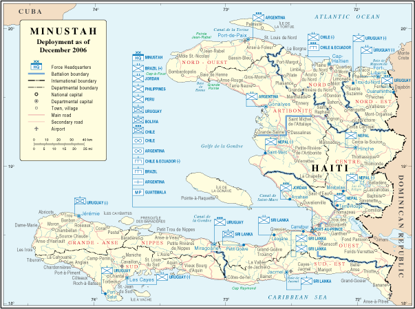
| توضیح | Map of Haiti | |||
| تاریخ | ||||
| منبع | http://www.un.org/Depts/Cartographic/map/dpko/minustah.pdf | |||
| سازنده | Department of Peacekeeping Operations Cartographic Section | |||
| اجازهنومه (این فایل جه دِباره استفاده هاکردن) |
|

فایل تاریخچه
تاریخ/زمونها سَر کلیک هاکنین تا اون گادِر ِنسخه ره هارشین.
| تاریخ/زمون | انگوس گتی | ابعاد | کارور | هارشا | |
|---|---|---|---|---|---|
| إسا | ۲۳ اکتبر ۲۰۰۷، ساعت ۰۲:۰۱ | | ۶۰۳ در ۴۴۹ (۱۸۱ کیلوبایت) | Jeroen | Bottom line is allowed according permissions by the UN: "UN maps are open source material and you can use them in your work or for making your own map. We request however that you '''delete the UN name and reference number upon any modification''' to the |
| ۲۲ ژانویه ۲۰۰۷، ساعت ۲۳:۱۷ |  | ۶۰۹ در ۴۶۶ (۱۸۱ کیلوبایت) | Cro-Cop2 | {{Information| |Description=Map of Haiti |Source=http://www.un.org/Depts/Cartographic/map/dpko/minustah.pdf |Date=December, 2006 |Author=Department of Peacekeeping Operations Cartographic Section |Permission={{UN map}} }} |
پروندهی استفاده بیّن
این صفحه لینک هِدانه این فایل ره:
پروندهی ِهمه جایی استفاده بییین
این ویکیون هم این پرونده جه استفاده کانّه:
- کاربرد bg.wikipedia.org دله
- کاربرد ca.wikipedia.org دله
- کاربرد ckb.wikipedia.org دله
- کاربرد de.wikipedia.org دله
- کاربرد en.wikipedia.org دله
- کاربرد en.wikinews.org دله
- کاربرد es.wikipedia.org دله
- کاربرد fa.wikipedia.org دله
- کاربرد fr.wikipedia.org دله
- کاربرد ht.wikipedia.org دله
- کاربرد id.wikipedia.org دله
- کاربرد nl.wikipedia.org دله
- کاربرد ru.wikipedia.org دله
- کاربرد www.wikidata.org دله