
پرونده:CIS mapwithnumbers.png
این پیش-پیش سِراق هدائن ِقایده: ۸۰۰ × ۵۴۷ پیکسل. دیگه کیفیتون: ۳۲۰ × ۲۱۹ پیکسل | ۶۴۰ × ۴۳۸ پیکسل | ۱٬۰۲۴ × ۷۰۱ پیکسل | ۱٬۳۵۶ × ۹۲۸ پیکسل.
اصلی پرونده (۱٬۳۵۶ × ۹۲۸ پـیـکـسهل, فـایـل گـأتـی: ۶۲ کیلوبایت, MIME مـونـد: image/png)
|
|
این پرونده ویکیتلمبار دله دَره. ونه دلهی بنویشتهئون (مازرونی) ره اینجه سِراق دنه. |
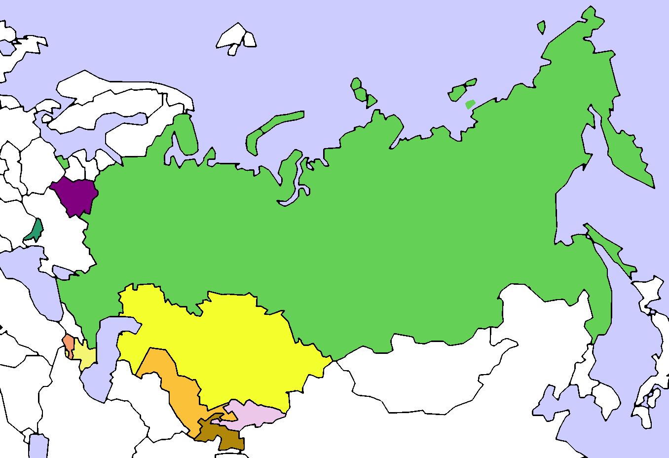
| توضیح | Map of the Commonwealth of Independent States (CIS). Created by User:Aris Katsaris, based on Image:Soviet Union Map.png |
| تاریخ | (UTC) |
| منبع | |
| سازنده |
|
| این یک عکس دستکاری شده است به این معنی که به صورت دیجیتالی از نسخهٔ اصلی تغییر یافتهاست. تغییرها: added colours and numbers. اصل آن را میتوان در اینجا مشاهده کرد: CIS Map.png. تغییرها توسط Lies Van Rompaey انجام شدهاست.
|
من، صاحب حقوق قانونی این اثر، به این وسیله این اثر را تحث اجازهنامهٔ ذیل منتشر میکنم:

|
کپی، پخش یا تغییر ِاجازه این سند وسّه تحت شرایط گنویِ آزاد مستندات ِمجوز، نسخهٔ ۱٫۲ یا هر نسخهٔ بعدتری که آزاد نرمافزارون بنیاد باوّه، منتشر بیه؛ بدون بخشهای نامتغیر، متون روی جلد، و متون پشت جلد، هدائه وانه. اتا کپی مجوز جه گنویِ آزاد مستندات ِمجوز ِبخش دله ضمیمه بیه. |
| این پرونده کریتیو کامانز اجازهنومه جه Attribution-Share Alike 3.0 سازگار نییه و منتشر بگردسته. | ||
| ||
| این برچسب مجوز بهعنوان بخشی از روزآمدسازی مجوز GFDL، به این پرونده افزوده شد. |
سیاهه بارگذاری اصلی
This image is a derivative work of the following images:
- File:_CIS_Map.png licensed with GFDL, GFDL/en
- 2008-08-14T21:32:15Z Voland77 1356x928 (110892 Bytes) update: according to the CIS treaty countries willing to exit the organization have to announce this intention 12 month before they can actually leave it.
- 2008-08-14T15:56:03Z Voland77 1356x928 (128298 Bytes) update (Georgia withdrawal)
- 2008-08-13T17:07:35Z Переход Артур 1356x928 (52266 Bytes) {{Information |Description=Map of the Commonwealth of Independent States (CIS). |Source= |Date= |Author=Created by [[User:Aris Katsaris]], based on [[:Image:Soviet Union Map.png]] |Permission= |other_versions= }} {{GFDL}} {
- 2008-08-12T21:54:56Z Akhristov 1356x928 (26542 Bytes) "Official Website" isn't working, I don't see how you checked. Let's quit this war. (Added Moldova as Associate Member)
- 2008-08-12T21:42:46Z Переход Артур 1356x928 (23233 Bytes) According to the official website of the organiazation Ukraine is a member of CIS
- 2008-08-12T21:35:52Z Akhristov 1356x928 (26564 Bytes) Reverted to version as of 21:34, 12 August 2008
- 2008-08-12T21:34:56Z Переход Артур 1356x928 (23233 Bytes) Ukraine is still a member of CIS
- 2008-08-12T21:34:41Z Akhristov 1356x928 (26564 Bytes) Ukraine is an Associate Member
- 2008-08-12T20:52:15Z Akhristov 1356x928 (26495 Bytes) {{Information |Description= |Source= |Date= |Author= |Permission= |other_versions= }}
- 2008-08-12T18:15:45Z Óðinn 1356x928 (23233 Bytes) Reverted to version as of 05:54, 3 July 2007 The formal process is yet to take place
- 2008-08-12T12:38:52Z Anthony040 1356x928 (62635 Bytes) {{Information |Description=The CIS following Georgia's decision to leave on August 12, 2008. |Source= |Date=August 12, 2008 |Author=Anthony040 |Permission= |other_versions= }}
- 2007-07-03T05:54:40Z PatrikR 1356x928 (23233 Bytes) losslessly optimized with [[:en:OptiPNG]]
- 2006-03-31T17:38:39Z Aris Katsaris 1356x928 (62664 Bytes) tweak in colors (purple full members, orangeish is associate member)
- 2005-04-13T21:25:41Z Aris Katsaris 1356x928 (37707 Bytes) Map of the Commonwealth of Independent States (CIS). Created by [[User:Aris Katsaris]], based on [[:Image:Soviet Union Map.png]] {{GFDL}}
Uploaded with derivativeFX
فایل تاریخچه
تاریخ/زمونها سَر کلیک هاکنین تا اون گادِر ِنسخه ره هارشین.
| تاریخ/زمون | انگوس گتی | ابعاد | کارور | هارشا | |
|---|---|---|---|---|---|
| إسا | ۱۹ مـارس ۲۰۱۴، ساعت ۲۱:۱۵ | | ۱٬۳۵۶ در ۹۲۸ (۶۲ کیلوبایت) | A2D2 | Update |
| ۱۷ ژانویه ۲۰۱۱، ساعت ۱۵:۰۷ |  | ۱٬۳۵۶ در ۹۲۸ (۶۶ کیلوبایت) | Maphobbyist | Georgia officially ceased to be a member of CIS in 2009, one year after it left the organization. | |
| ۳۰ ژانویه ۲۰۰۹، ساعت ۱۹:۳۶ |  | ۱٬۳۵۶ در ۹۲۸ (۴۳ کیلوبایت) | Lies Van Rompaey | {{Information |Description=Map of the Commonwealth of Independent States (CIS). Created by User:Aris Katsaris, based on Image:Soviet Union Map.png |Source=*File:_CIS_Map.png |Date=2009-01-30 19:33 (UTC) |Author=*File:_CIS_Map.png: '' |
پروندهی استفاده بیّن
این صفحه لینک هِدانه این فایل ره:
پروندهی ِهمه جایی استفاده بییین
این ویکیون هم این پرونده جه استفاده کانّه:
- کاربرد ca.wikipedia.org دله
- کاربرد ckb.wikipedia.org دله
- کاربرد en.wikipedia.org دله
- کاربرد fa.wikipedia.org دله
- کاربرد id.wikipedia.org دله
- کاربرد ka.wikipedia.org دله
- کاربرد nl.wikipedia.org دله
- کاربرد sh.wikipedia.org دله
- کاربرد tg.wikipedia.org دله
- کاربرد www.wikidata.org دله