
پرونده:Capricornus constellation map.png

اصلی پرونده (۲٬۲۶۹ × ۱٬۹۸۹ پـیـکـسهل, فـایـل گـأتـی: ۸۴ کیلوبایت, MIME مـونـد: image/png)
|
|
این پرونده ویکیتلمبار دله دَره. ونه دلهی بنویشتهئون (مازرونی) ره اینجه سِراق دنه. |
Copyright © 2003 Torsten Bronger.
It was created by Torsten Bronger using the program PP3 on 2003/08/18. At PP3's homepage, you also get the input scripts necessary for re-compiling the map.
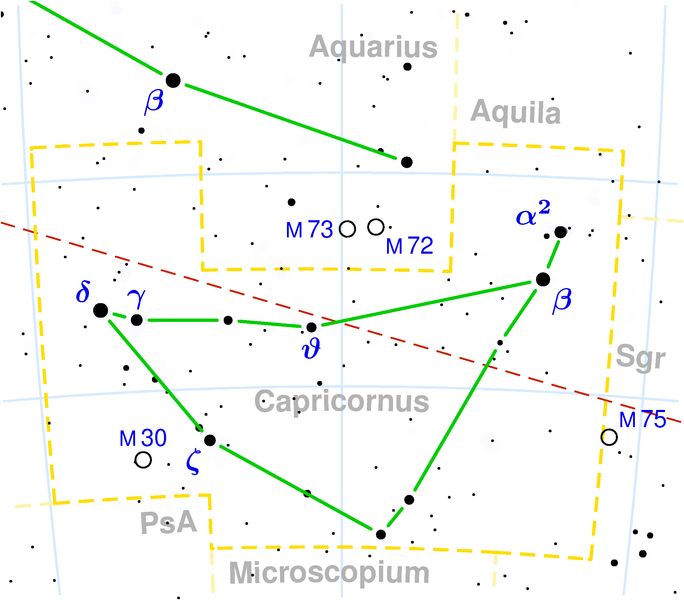
The yellow dashed lines are constellation boundaries, the red dashed line is the ecliptic, and the shades of blue show Milky Way areas of different brightness. The map contains all Messier objects, except for colliding ones. The underlying database contains all stars brighter than 6.5. All coordinates refer to equinox 2000.0.
The map is calculated with the equidistant azimuthal projection (the zenith being in the center of the image). The north pole is to the top. The (horizontal) lines of equal declination are drawn for 0°, ±10°, ±20° etc. The lines of equal rectascension are drawn for all 24 hours. Towards the rim there is a very slight magnification (and distortion).

|
File:Capricornus constellation map.svg یک نسخهٔ برداری از این پرونده است.
آن پرونده را هنگامی که بهتر بود میبایست به جای این نسخهٔ تصویر استفاده کرد. File:Capricornus constellation map.png → File:Capricornus constellation map.svg
برای کسب اطلاعات بیشتر در ارتباط با تصاویر برداری لطفاً اینجا را مطالعهکنید. همچنین اطلاعات بیشتری در ارتباط با حمایت مدیاویکی از تصاویر اسویجی وجود دارد. |
 |

|
کپی، پخش یا تغییر ِاجازه این سند وسّه تحت شرایط گنویِ آزاد مستندات ِمجوز، نسخهٔ ۱٫۲ یا هر نسخهٔ بعدتری که آزاد نرمافزارون بنیاد باوّه، منتشر بیه؛ بدون بخشهای نامتغیر، متون روی جلد، و متون پشت جلد، هدائه وانه. اتا کپی مجوز جه گنویِ آزاد مستندات ِمجوز ِبخش دله ضمیمه بیه. |
| این پرونده کریتیو کامانز اجازهنومه جه Attribution-Share Alike 3.0 سازگار نییه و منتشر بگردسته. | ||
| ||
| این برچسب مجوز بهعنوان بخشی از روزآمدسازی مجوز GFDL، به این پرونده افزوده شد. |
فایل تاریخچه
تاریخ/زمونها سَر کلیک هاکنین تا اون گادِر ِنسخه ره هارشین.
| تاریخ/زمون | انگوس گتی | ابعاد | کارور | هارشا | |
|---|---|---|---|---|---|
| إسا | ۳ مه ۲۰۲۲، ساعت ۰۸:۰۸ | | ۲٬۲۶۹ در ۱٬۹۸۹ (۸۴ کیلوبایت) | Ayyur | Separation line between alpha1 and alpha2 added (visible in higher resolutions) |
| ۱۲ دسامبر ۲۰۰۴، ساعت ۱۸:۰۰ |  | ۲٬۲۶۹ در ۱٬۹۸۹ (۸۳ کیلوبایت) | Alfio | Capricornus constellation map |
پروندهی استفاده بیّن
این صفحه لینک هِدانه این فایل ره:
پروندهی ِهمه جایی استفاده بییین
این ویکیون هم این پرونده جه استفاده کانّه:
- کاربرد af.wikipedia.org دله
- کاربرد ast.wikipedia.org دله
- کاربرد be.wikipedia.org دله
- کاربرد bg.wikipedia.org دله
- کاربرد br.wikipedia.org دله
- کاربرد ca.wikipedia.org دله
- کاربرد ce.wikipedia.org دله
- کاربرد co.wikipedia.org دله
- کاربرد cs.wikipedia.org دله
- کاربرد da.wikipedia.org دله
- کاربرد de.wikipedia.org دله
- کاربرد el.wikipedia.org دله
- کاربرد el.wiktionary.org دله
- کاربرد en.wikipedia.org دله
- کاربرد en.wiktionary.org دله
- کاربرد et.wikipedia.org دله
- کاربرد eu.wikipedia.org دله
- کاربرد fa.wikipedia.org دله
- کاربرد fi.wikipedia.org دله
- کاربرد frr.wikipedia.org دله
- کاربرد ga.wikipedia.org دله
- کاربرد gl.wikipedia.org دله
- کاربرد he.wiktionary.org دله
- کاربرد hr.wikipedia.org دله
- کاربرد hu.wikipedia.org دله
- کاربرد it.wikipedia.org دله
- کاربرد it.wiktionary.org دله
- کاربرد ja.wikipedia.org دله
سراسری استفادهئون ره این پرونده جه سِراق هاده.