
پرونده:Palau.PNG
اصلی پرونده (۶۲۶ × ۸۳۲ پـیـکـسهل, فـایـل گـأتـی: ۴۷ کیلوبایت, MIME مـونـد: image/png)
|
|
این پرونده ویکیتلمبار دله دَره. ونه دلهی بنویشتهئون (مازرونی) ره اینجه سِراق دنه. |

|
این پرونده توسط File:Un-palau.png جایگزین شدهاست. توصیه میشود که پروندهٔ دیگر را استفاده کنید. توجه داشته باشید که پاک کردن نگارههای جایگرین شده به رضایت نیاز دارد. دلیل استفاده از پروندهٔ دیگر: "Updated, and much better quality and resolution"
|

|
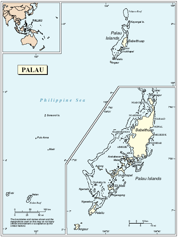
Mapa de la República de Palau.
Fuente: http://www.un.org/Depts/Cartographic/map/profile/palau.pdf
| This image is a map derived from a United Nations map.
Unless stated otherwise, UN maps are to be considered in the public domain. This applies worldwide. UN maps are, in principle, open source material and you can use them in your work or for making your own map. UN requests however that you delete the UN name, logo and reference number upon any modification to the map. Content of your map will be your responsibility. You can state in your publication, if you wish, something like: based on UN map … (map name, map number, revision number and date). See: Geospatial Information Section. And: Geospatial, location data for a better world. |
 |
فایل تاریخچه
تاریخ/زمونها سَر کلیک هاکنین تا اون گادِر ِنسخه ره هارشین.
| تاریخ/زمون | انگوس گتی | ابعاد | کارور | هارشا | |
|---|---|---|---|---|---|
| إسا | ۲۳ مه ۲۰۰۵، ساعت ۰۰:۵۴ | | ۶۲۶ در ۸۳۲ (۴۷ کیلوبایت) | Taichi | Mapa de la República de Palau. Fuente: http://www.un.org/Depts/Cartographic/map/profile/palau.pdf {{PD}} |
پروندهی استفاده بیّن
این صفحه لینک هِدانه این فایل ره:
پروندهی ِهمه جایی استفاده بییین
این ویکیون هم این پرونده جه استفاده کانّه:
- کاربرد ar.wikipedia.org دله
- کاربرد ban.wikipedia.org دله
- کاربرد ca.wikipedia.org دله
- کاربرد ckb.wikipedia.org دله
- کاربرد de.wikipedia.org دله
- کاربرد en.wikipedia.org دله
- کاربرد fa.wikipedia.org دله
- کاربرد hu.wikipedia.org دله
- کاربرد id.wikipedia.org دله
- کاربرد ja.wikipedia.org دله
- کاربرد lfn.wikipedia.org دله
- کاربرد nl.wikipedia.org دله
- کاربرد tg.wikipedia.org دله
- کاربرد uk.wikipedia.org دله
- کاربرد www.wikidata.org دله
- کاربرد zh.wikipedia.org دله