
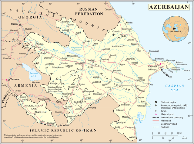
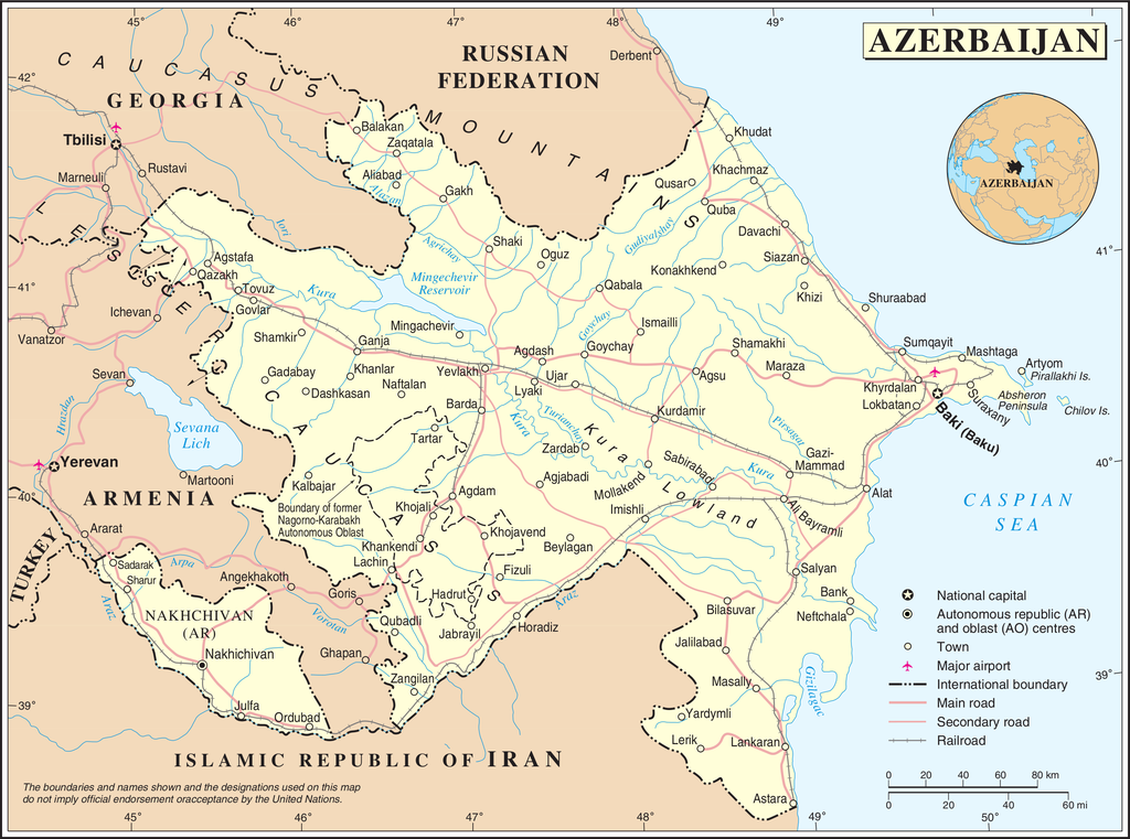
پرونده:Un-azerbaijan.png

اصلی پرونده (۳٬۰۳۷ × ۲٬۲۵۷ پـیـکـسهل, فـایـل گـأتـی: ۱٫۵۶ مگابایت, MIME مـونـد: image/png)
|
|
این پرونده ویکیتلمبار دله دَره. ونه دلهی بنویشتهئون (مازرونی) ره اینجه سِراق دنه. |
| This image is a map derived from a United Nations map.
Unless stated otherwise, UN maps are to be considered in the public domain. This applies worldwide. UN maps are, in principle, open source material and you can use them in your work or for making your own map. UN requests however that you delete the UN name, logo and reference number upon any modification to the map. Content of your map will be your responsibility. You can state in your publication, if you wish, something like: based on UN map … (map name, map number, revision number and date). See: Geospatial Information Section. And: Geospatial, location data for a better world. |
 |
فایل تاریخچه
تاریخ/زمونها سَر کلیک هاکنین تا اون گادِر ِنسخه ره هارشین.
| تاریخ/زمون | انگوس گتی | ابعاد | کارور | هارشا | |
|---|---|---|---|---|---|
| إسا | ۲۳ اکتبر ۲۰۰۷، ساعت ۰۲:۵۰ | | ۳٬۰۳۷ در ۲٬۲۵۷ (۱٫۵۶ مگابایت) | Jeroen | {{UN map}} Category:Maps of Azerbaijan |
پروندهی استفاده بیّن
این صفحه لینک هِدانه این فایل ره:
پروندهی ِهمه جایی استفاده بییین
این ویکیون هم این پرونده جه استفاده کانّه:
- کاربرد bn.wikipedia.org دله
- کاربرد ce.wikipedia.org دله
- کاربرد da.wikipedia.org دله
- کاربرد de.wikipedia.org دله
- کاربرد en.wikipedia.org دله
- کاربرد fi.wikipedia.org دله
- کاربرد fr.wikipedia.org دله
- کاربرد gag.wikipedia.org دله
- کاربرد gom.wikipedia.org دله
- کاربرد he.wikipedia.org دله
- کاربرد ka.wikipedia.org دله
- کاربرد nds.wikipedia.org دله
- کاربرد nn.wikipedia.org دله
- کاربرد no.wikipedia.org دله
- کاربرد pcd.wikipedia.org دله
- کاربرد pl.wiktionary.org دله
- Azerbaijan
- アゼルバイジャン
- Азербайджан
- Azərbaycan
- אַזערבײַדזשאַן
- Azerbejdżan
- Azerbaidjan
- Αζερμπαϊτζάν
- Azerbajdzsán
- Azerbaidžan
- Azerbaidzhan
- Azerbajdzjan
- Azzirbaiggian
- 아제르바이잔
- Azerbaiyán
- Азербејџан
- Azerbaïdjan
- 아제르바이쟌
- Azerbaidžanas
- აზერბაიჯანი
- Azerbayǧan
- أذربيجان
- Aserbajdsjan
- ʻAkepaikana
- آذربایجان
- آذربائیجان
- Azerbaycan
- Azerbaijão
- Azerbajdžan
سراسری استفادهئون ره این پرونده جه سِراق هاده.