
پرونده:Un-ethiopia.png
اصلی پرونده (۳٬۰۳۸ × ۲٬۲۵۷ پـیـکـسهل, فـایـل گـأتـی: ۱٫۶ مگابایت, MIME مـونـد: image/png)
|
|
این پرونده ویکیتلمبار دله دَره. ونه دلهی بنویشتهئون (مازرونی) ره اینجه سِراق دنه. |
کار ِگزارش
| توضیح |
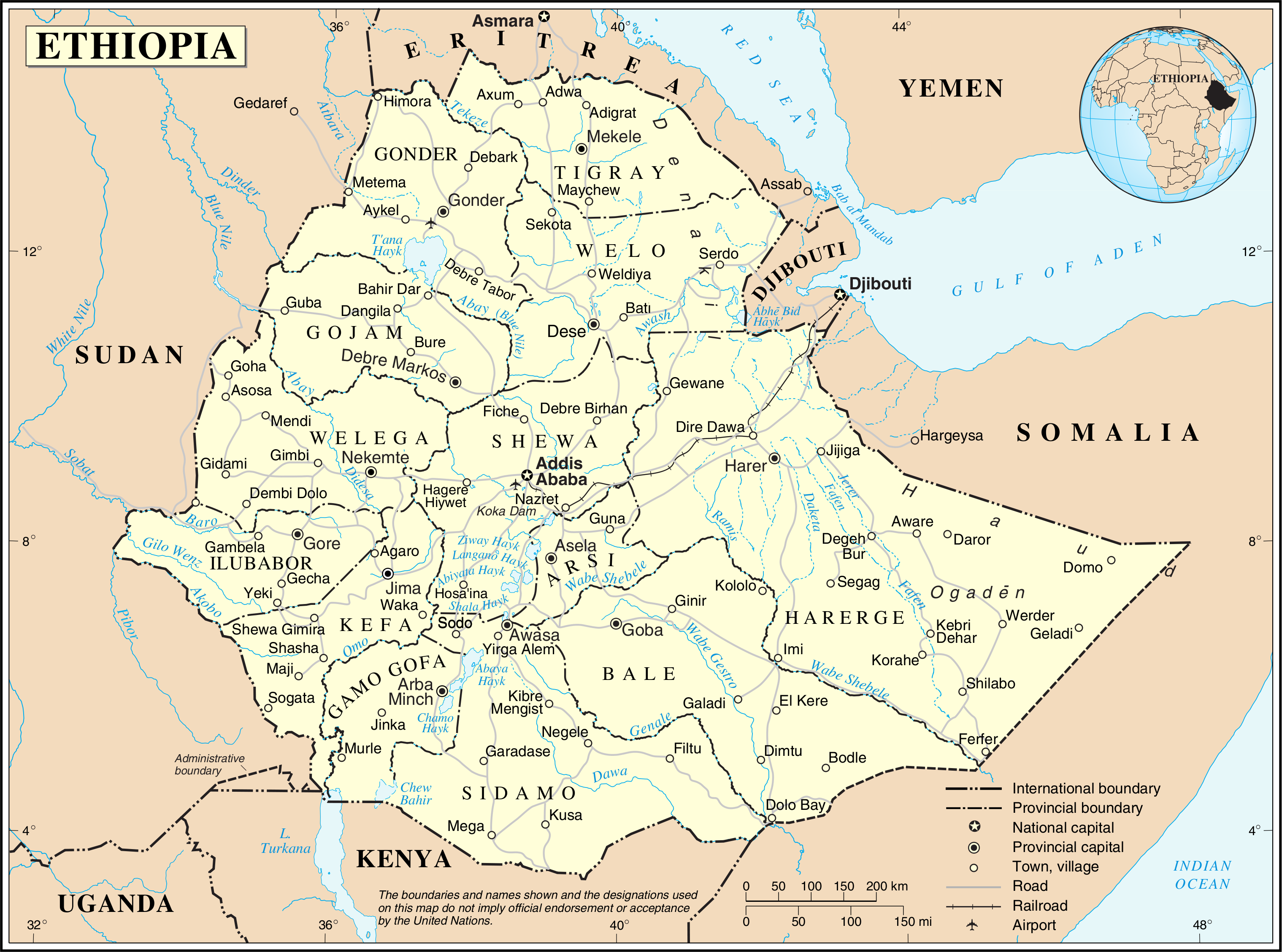
English: This map is not up to date. The internal borders show the provinces which were replaced by regions/states in 1995.
Nederlands: Deze kaart is verouderd. De interne grenzen tonen de provincies die in 1995 werden vervangen door regio's/staten. |
|||
| تاریخ | ||||
| منبع | The United Nations Cartographic Section (UNCS) | |||
| سازنده | Cartographer of the United Nations | |||
| اجازهنومه (این فایل جه دِباره استفاده هاکردن) |
|

فایل تاریخچه
تاریخ/زمونها سَر کلیک هاکنین تا اون گادِر ِنسخه ره هارشین.
| تاریخ/زمون | انگوس گتی | ابعاد | کارور | هارشا | |
|---|---|---|---|---|---|
| إسا | ۲۴ اکتبر ۲۰۰۷، ساعت ۰۱:۰۰ | | ۳٬۰۳۸ در ۲٬۲۵۷ (۱٫۶ مگابایت) | Jeroen | {{UN map}} Category:Maps of Ethiopia |
پروندهی استفاده بیّن
این صفحه لینک هِدانه این فایل ره:
پروندهی ِهمه جایی استفاده بییین
این ویکیون هم این پرونده جه استفاده کانّه:
- کاربرد ca.wikipedia.org دله
- کاربرد ckb.wikipedia.org دله
- کاربرد en.wikipedia.org دله
- کاربرد eo.wikipedia.org دله
- کاربرد fa.wikipedia.org دله
- کاربرد fr.wikipedia.org دله
- کاربرد id.wikipedia.org دله
- کاربرد nl.wikipedia.org دله
- کاربرد pl.wiktionary.org دله
- کاربرد uk.wikipedia.org دله
- کاربرد ur.wikipedia.org دله
- کاربرد vi.wikipedia.org دله
- کاربرد www.wikidata.org دله