
پرونده:Un-guatemala.png
اصلی پرونده (۲٬۴۹۳ × ۲٬۹۴۷ پـیـکـسهل, فـایـل گـأتـی: ۱٫۸ مگابایت, MIME مـونـد: image/png)
|
|
این پرونده ویکیتلمبار دله دَره. ونه دلهی بنویشتهئون (مازرونی) ره اینجه سِراق دنه. |
| This image is a map derived from a United Nations map.
Unless stated otherwise, UN maps are to be considered in the public domain. This applies worldwide. UN maps are, in principle, open source material and you can use them in your work or for making your own map. UN requests however that you delete the UN name, logo and reference number upon any modification to the map. Content of your map will be your responsibility. You can state in your publication, if you wish, something like: based on UN map … (map name, map number, revision number and date). See: Geospatial Information Section. And: Geospatial, location data for a better world. |
 |
| توضیح |
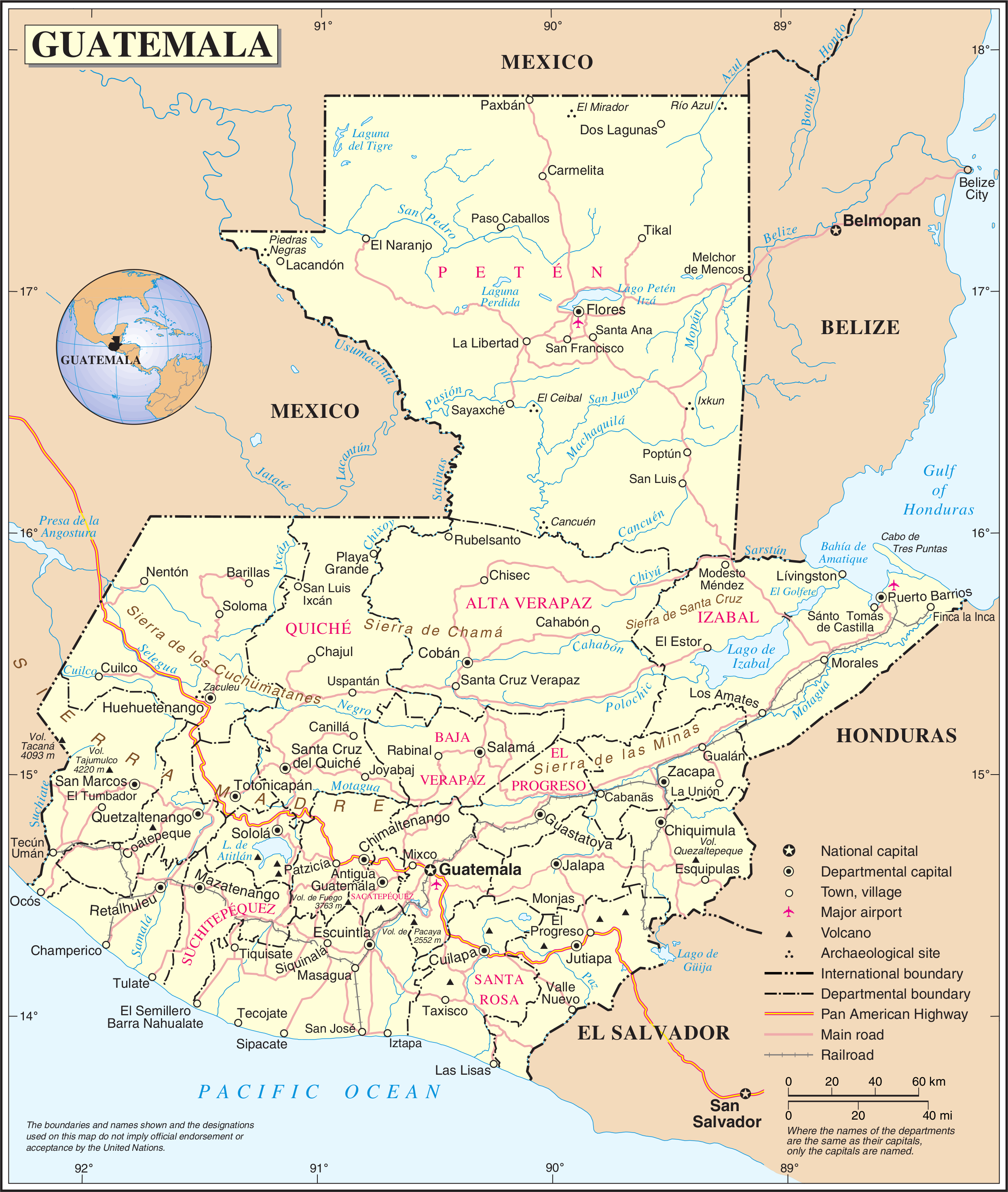
English: Political map of Guatemala generated by the United Nations. |
| تاریخ | |
| منبع | United Nations Geospatial Information Section |
| سازنده | United Nations Department of Peacekeeping Operations Cartographic Section |
فایل تاریخچه
تاریخ/زمونها سَر کلیک هاکنین تا اون گادِر ِنسخه ره هارشین.
| تاریخ/زمون | انگوس گتی | ابعاد | کارور | هارشا | |
|---|---|---|---|---|---|
| إسا | ۲۴ اکتبر ۲۰۰۷، ساعت ۰۱:۰۴ | | ۲٬۴۹۳ در ۲٬۹۴۷ (۱٫۸ مگابایت) | Jeroen | {{UN map}} Category:Maps of Guatemala |
پروندهی استفاده بیّن
این صفحه لینک هِدانه این فایل ره:
پروندهی ِهمه جایی استفاده بییین
این ویکیون هم این پرونده جه استفاده کانّه:
- کاربرد af.wikipedia.org دله
- کاربرد ar.wikipedia.org دله
- کاربرد be-tarask.wikipedia.org دله
- کاربرد ckb.wikipedia.org دله
- کاربرد el.wikipedia.org دله
- کاربرد en.wikipedia.org دله
- Geography of Guatemala
- List of places in Guatemala
- Carlos Castillo Armas
- 1954 Guatemalan coup d'état
- Water supply and sanitation in Guatemala
- Outline of Guatemala
- Guatemala
- List of rivers of Guatemala
- Index of Guatemala-related articles
- Water resources management in Guatemala
- United Nations Security Council Resolution 1094
- User:Nlyemica/sandbox
- کاربرد es.wikipedia.org دله
- کاربرد fa.wikipedia.org دله
- کاربرد fi.wikipedia.org دله
- کاربرد gom.wikipedia.org دله
- کاربرد id.wikipedia.org دله
- کاربرد kbp.wikipedia.org دله
- کاربرد kn.wikipedia.org دله
- کاربرد lez.wikipedia.org دله
- کاربرد nl.wikipedia.org دله
- کاربرد pl.wiktionary.org دله
- کاربرد ro.wikipedia.org دله
- کاربرد ru.wikipedia.org دله
- کاربرد sl.wikipedia.org دله
- کاربرد ta.wikipedia.org دله
- کاربرد te.wikipedia.org دله
- کاربرد to.wikipedia.org دله
- کاربرد uk.wikipedia.org دله
- کاربرد uk.wiktionary.org دله
- کاربرد www.wikidata.org دله
سراسری استفادهئون ره این پرونده جه سِراق هاده.