
پرونده:Falkland Islands map from CIA World Factbook.png
ویشته رٮزولیشٮن ندارنه.
Falkland_Islands_map_from_CIA_World_Factbook.png (۳۲۸ × ۳۵۲ پـیـکـسهل, فـایـل گـأتـی: ۹ کیلوبایت, MIME مـونـد: image/png)
|
|
این پرونده ویکیتلمبار دله دَره. ونه دلهی بنویشتهئون (مازرونی) ره اینجه سِراق دنه. |
گزارش
| توضیح |
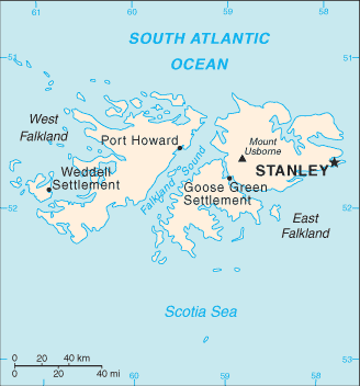
English: Falkland Islands map from CIA World Factbook |
| منبع | CIA World Factbook |
| سازنده | CIA |
اجازهنومه
This image is in the public domain because it contains materials that originally came from the United States Central Intelligence Agency's World Factbook.
|
 |
سیاهه بارگذاری اصلی
The original description page was here. All following user names refer to en.wikipedia.
- 2007-06-19 20:12 PNG crusade bot 328×352× (9504 bytes) {{PD-USGov}} [[sr:Слика:Falklands Map.gif]] == Automatically converted to PNG == The [[User:PNG crusade bot|PNG crusade bot]] automatically converted this image to the more efficient [[PNG]] format. The image was previously uploaded as "F
فایل تاریخچه
تاریخ/زمونها سَر کلیک هاکنین تا اون گدِر ِنسخه ره هارشین.
| تاریخ/زمون | انگوسگتی | ابعاد | کارور | توضیح | |
|---|---|---|---|---|---|
| إسا | ۱۸ مه ۲۰۱۱، ساعت ۲۲:۱۲ | | ۳۲۸ در ۳۵۲ (۹ کیلوبایت) | File Upload Bot (Magnus Manske) | {{BotMoveToCommons|en.wikipedia|year={{subst:CURRENTYEAR}}|month={{subst:CURRENTMONTHNAME}}|day={{subst:CURRENTDAY}}}} {{Information |Description={{en|__NOTOC__ en:sr:Слика:Falklands Map.gif == Automatically converted to PNG == The [[:en:Use |
پروندهی استفاده
این صفحه لینک هِدانه این فایل ره:
پروندهیِ گِردِ استفادهئون
این ویکیون هم این پرونده جه استفاده کانّه:
- کاربرد ar.wikipedia.org دله
- کاربرد arz.wikipedia.org دله
- کاربرد ast.wikipedia.org دله
- کاربرد ca.wikipedia.org دله
- کاربرد ceb.wikipedia.org دله
- کاربرد de.wikipedia.org دله
- کاربرد el.wikipedia.org دله
- کاربرد en.wikipedia.org دله
- کاربرد eo.wikipedia.org دله
- کاربرد es.wikipedia.org دله
- کاربرد eu.wikipedia.org دله
- کاربرد fa.wikipedia.org دله
- کاربرد fr.wikipedia.org دله
- کاربرد fy.wikipedia.org دله
- کاربرد gl.wikipedia.org دله
- کاربرد hu.wikipedia.org دله
- کاربرد it.wikipedia.org دله
- کاربرد lt.wiktionary.org دله
- کاربرد pl.wikipedia.org دله
- کاربرد pt.wikipedia.org دله
- کاربرد ro.wikipedia.org دله
- کاربرد sv.wikipedia.org دله
- کاربرد uk.wikipedia.org دله
- کاربرد ur.wikipedia.org دله
- کاربرد vi.wikipedia.org دله
- کاربرد www.wikidata.org دله