
پرونده:Glendora, California (7134837923).jpg

اصلی پرونده (۱٬۶۰۰ × ۱٬۰۶۳ پـیـکـسهل, فـایـل گـأتـی: ۶۶۶ کیلوبایت, MIME مـونـد: image/jpeg)
|
|
این پرونده ویکیتلمبار دله دَره. ونه دلهی بنویشتهئون (مازرونی) ره اینجه سِراق دنه. |
.jpg)
.jpg?uselang=mzn)
گزارش
| توضیح |
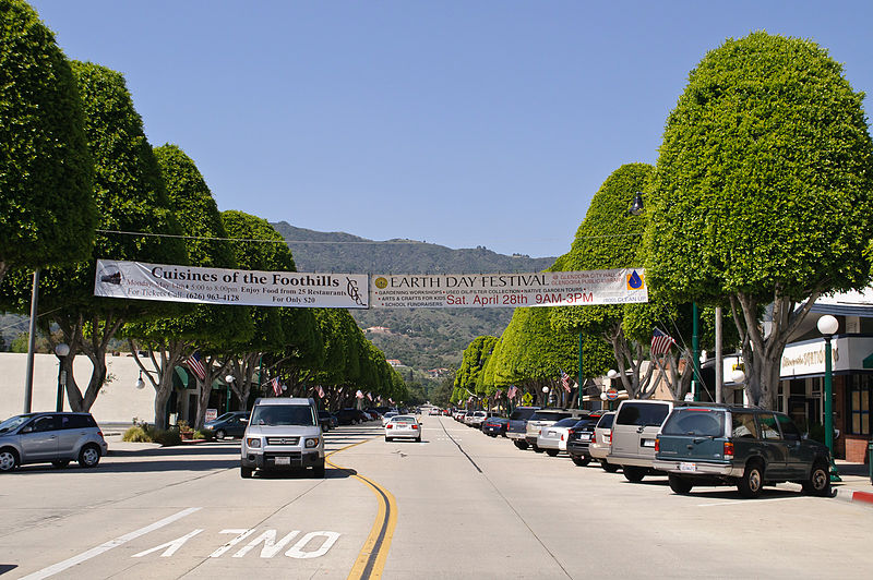
Looking north from Civic Center along Glendora Avenue, which is the historical shopping area that still is home to mom-and-pop stores. I am paying a visit to Glendora, located along the old Route 66 at the eastern edge of San Gabriel Valley, during its Earth Day festival. While San Gabriel Valley as a whole has gone through growth and demographic changes over the years, Glendora has retained the feel of San Gabriel Valley of yore; its population is smaller, its historic town core remains vibrant, and it is also a rare San Gabriel Valley city that remains majority white. My favorite singer-songwriter Anna Nalick grew up here in Glendora. And part of my Glendora visit is to soak up the same influences and vibes that had inspired Anna's songwriting. Following the vibes that have inspired my favorite musicians will now be a new twist to my future travels; in fact my Glendora visit is sort of a practice run for my visit to Huntington, Long Island, New York, just over a week later - where my longtime idol Mariah Carey grew up. |
| تاریخ | |
| منبع | Glendora, California |
| سازنده | InSapphoWeTrust from Los Angeles, California, USA |
| مختصات دوربین | | محل قرارگیری این نگاره و سایر نگارهها در: نقشهٔ شهری باز |
|---|
.jpg¶ms=034.135909_N_-117.865276_E_globe:Earth_type:camera_source:Flickr_&language=mzn)
اجازهنومه
- شما اجازه دارنی:
- همباز بیّن وسّه – پروندهی ِکپی، توزیع و انتقال وسّه
- پشو بزوئن – پروندهی انطباق وسّه
- این شرایط جه:
- تخصیص – شما ونه اتجور بنویسین که اثر ِصاحاب ره نسبت هِدا بَوو، نا اینکه اتی بنویسین که مخاطبون فکر هاکنِن اون آدِم شمه بنویشته ره تأیید کانده.
- همباز هاکردن – اگه عکس سَر فقط اتکه تغییر هِدانی، بتونّی همون مجوز جه استفاده هاکنین.
| This image, originally posted to Flickr, was reviewed on 27 January 2013 by the administrator or reviewer File Upload Bot (Magnus Manske), who confirmed that it was available on Flickr under the stated license on that date. |
فایل تاریخچه
تاریخ/زمونها سَر کلیک هاکنین تا اون گدِر ِنسخه ره هارشین.
| تاریخ/زمون | انگوسگتی | ابعاد | کارور | توضیح | |
|---|---|---|---|---|---|
| إسا | ۲۷ ژانویه ۲۰۱۳، ساعت ۱۶:۰۲ | | ۱٬۶۰۰ در ۱٬۰۶۳ (۶۶۶ کیلوبایت) | File Upload Bot (Magnus Manske) | Transferred from Flickr by User:russavia |
پروندهی استفاده
این صفحه لینک هِدانه این فایل ره:
پروندهیِ گِردِ استفادهئون
این ویکیون هم این پرونده جه استفاده کانّه:
- کاربرد ar.wikipedia.org دله
- کاربرد arz.wikipedia.org دله
- کاربرد bg.wikipedia.org دله
- کاربرد ca.wikipedia.org دله
- کاربرد ceb.wikipedia.org دله
- کاربرد ce.wikipedia.org دله
- کاربرد eo.wikipedia.org دله
- کاربرد eu.wikipedia.org دله
- کاربرد fr.wikipedia.org دله
- کاربرد glk.wikipedia.org دله
- کاربرد he.wikipedia.org دله
- کاربرد ht.wikipedia.org دله
- کاربرد hu.wikipedia.org دله
- کاربرد hy.wikipedia.org دله
- کاربرد it.wikipedia.org دله
- کاربرد lld.wikipedia.org دله
- کاربرد no.wikipedia.org دله
- کاربرد pl.wikipedia.org دله
- کاربرد pt.wikipedia.org دله
- کاربرد ro.wikipedia.org دله
- کاربرد ru.wikipedia.org دله
- کاربرد sr.wikipedia.org دله
- کاربرد tr.wikipedia.org دله
- کاربرد tt.wikipedia.org دله
- کاربرد uz.wikipedia.org دله
- کاربرد vo.wikipedia.org دله
- کاربرد www.wikidata.org دله
- کاربرد zh-min-nan.wikipedia.org دله
.jpg)