
پرونده:Lombardy.satellite.jpg

این پیش-پیش سِراق هدائن ِقایده: ۶۰۰ × ۶۰۰ پیکسل. دیگه کیفیتون: ۲۴۰ × ۲۴۰ پیکسل | ۴۸۰ × ۴۸۰ پیکسل | ۷۶۸ × ۷۶۸ پیکسل | ۱٬۰۲۴ × ۱٬۰۲۴ پیکسل | ۲٬۰۴۸ × ۲٬۰۴۸ پیکسل | ۴٬۰۵۵ × ۴٬۰۵۵ پیکسل.
اصلی پرونده (۴٬۰۵۵ × ۴٬۰۵۵ پـیـکـسهل, فـایـل گـأتـی: ۱۵٫۲ مگابایت, MIME مـونـد: image/jpeg)
|
|
این پرونده ویکیتلمبار دله دَره. ونه دلهی بنویشتهئون (مازرونی) ره اینجه سِراق دنه. |
کار ِگزارش
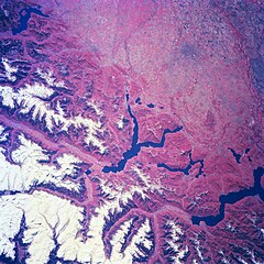
| توضیح | Several elongated lakes (dark features) are identifiable in this southerly view of the Italian-Swiss border. The elongated lakes are the creation of alpine (or valley) glaciers that moved generally southward through this section of the Italian Alps over 12000 years ago. From west to east the four larger lakes are Maggiore (lower right corner), Lugana, Como, and d'Iseo (upper left corner). Smaller lakes (also dark features) are visible at the southern end of Lake Como (center of image) and Lake Maggiore. Subtle faults that are perpendicular to the southern end of the lakes can be traced east to west across the landscape at the base of the Italian Alps. Glaciated, U-shaped valleys are discernible north and northeast of the lakes. The color infrared helps to identify the densely vegetated mountain slopes where the forested land (green vegetation) is shown as concentrations of reddish patterns. The relatively flat plains of the highly industrialized and agriculturally productive Po River Valley (upper third of image) presents a dramatically different looking terrain than the snow covered mountainous region of northern Italy. |
| تاریخ | Winter/Spring 1997 |
| منبع | Here |
| سازنده | Image Science and Analysis Laboratory, NASA-Johnson Space Center. 18 Mar. 2005. "Earth from Space - Image Information." |
این نگاره یا ویدیو توسط یکی از مراکز سازمان ملی هوانوردی و فضایی (NASA)ایالات متحدهٔ آمریکا تحت شناسهٔ عکس: NM23-776-834کاتالوگ شدهاست. این برچست وضعیت حق تکثیر اثر ضمیمه شده را مشخص نمیکند. یک برچسپ معمولی همچنان مورد نیاز است. Commons:Licensing را برای کسب اطلاعات مشاهده فرمایید. زبانهای دیگر:
|
اجازهنومه
| این پرونده در مالکیت عمومی قرار دارد چرا که توسط ناسا ایجاد شده است. سیاست حق تکثیر ناسا بیان میکند که «مواد ناسا با حق تکثیر محافظت نمیشوند، مگراینکه ذکر شده باشد». (Template:PD-USGov، صفحهٔ سیاست حق تکثیر ناسا یا سیاست جیپیال استفاده از تصاویر را ببینید.) | ||
 |
هشدارها:
|
فایل تاریخچه
تاریخ/زمونها سَر کلیک هاکنین تا اون گدِر ِنسخه ره هارشین.
| تاریخ/زمون | انگوسگتی | ابعاد | کارور | توضیح | |
|---|---|---|---|---|---|
| إسا | ۲۴ ژوئیه ۲۰۲۳، ساعت ۲۱:۱۸ | | ۴٬۰۵۵ در ۴٬۰۵۵ (۱۵٫۲ مگابایت) | Don-vip | |
| ۵ آگوست ۲۰۰۶، ساعت ۱۹:۰۵ |  | ۶۳۹ در ۶۳۹ (۳۹۱ کیلوبایت) | Lange~commonswiki | {{Information |Description= Several elongated lakes (dark features) are identifiable in this southerly view of the Italian-Swiss border. The elongated lakes are the creation of alpine (or valley) glaciers that moved generally southward through this sectio |
پروندهی استفاده
این صفحه لینک هِدانه این فایل ره:
پروندهیِ گِردِ استفادهئون
این ویکیون هم این پرونده جه استفاده کانّه:
- کاربرد ar.wikipedia.org دله
- کاربرد arz.wikipedia.org دله
- کاربرد ast.wikipedia.org دله
- کاربرد az.wikipedia.org دله
- کاربرد bg.wikipedia.org دله
- کاربرد ca.wikipedia.org دله
- کاربرد cy.wikipedia.org دله
- کاربرد de.wikivoyage.org دله
- کاربرد diq.wikipedia.org دله
- کاربرد fi.wikipedia.org دله
- کاربرد fr.wikipedia.org دله
- کاربرد fr.wikivoyage.org دله
- کاربرد ga.wikipedia.org دله
- کاربرد gd.wikipedia.org دله
- کاربرد gl.wikipedia.org دله
- کاربرد he.wikipedia.org دله
- کاربرد hy.wikipedia.org دله
- کاربرد ia.wikipedia.org دله
- کاربرد id.wikipedia.org دله
- کاربرد ilo.wikipedia.org دله
- کاربرد it.wikipedia.org دله
- کاربرد ka.wikipedia.org دله
- کاربرد ku.wikipedia.org دله
- کاربرد la.wikipedia.org دله
- کاربرد nn.wikipedia.org دله
- کاربرد no.wikipedia.org دله
- کاربرد oc.wikipedia.org دله
- کاربرد pl.wikipedia.org دله
- کاربرد ro.wikipedia.org دله
- کاربرد ru.wikipedia.org دله
- کاربرد ru.wikinews.org دله
- کاربرد sl.wikipedia.org دله
- کاربرد sr.wikipedia.org دله
- کاربرد tt.wikipedia.org دله
- کاربرد uk.wikipedia.org دله
- کاربرد vec.wikipedia.org دله
- کاربرد vi.wikipedia.org دله
- کاربرد www.wikidata.org دله