
پرونده:Mayotte, vue par Sentinel 2 (cropped).jpg

اصلی پرونده (۴٬۱۰۰ × ۴٬۳۸۱ پـیـکـسهل, فـایـل گـأتـی: ۱۱٫۶۷ مگابایت, MIME مـونـد: image/jpeg)
|
|
این پرونده ویکیتلمبار دله دَره. ونه دلهی بنویشتهئون (مازرونی) ره اینجه سِراق دنه. |
گزارش
| توضیح |
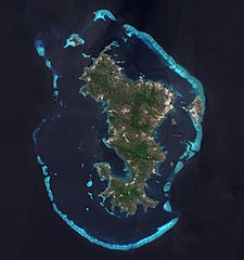
Français : L'ile de Mayotte dans l’océan indien vue par le satellite Sentinel 2, le 14 aout 2021.
English: Mayotte island (Indian Ocean) photographed by satellite Sentinel 2 on 14th August 2021. |
| تاریخ | |
| منبع | https://phototheque.cnes.fr/cnes/media/68576 |
| سازنده | European Space Agency / CNES |
| دیگر نسخهها |
_(cropped).jpg)

.jpg)
.jpg?uselang=mzn)
| مختصات دوربین | | محل قرارگیری این نگاره و سایر نگارهها در: نقشهٔ شهری باز |
|---|
.jpg¶ms=-12.843056_N_0045.138333_E_globe:Earth_type:camera__&language=mzn)
اجازهنومه

|
This image contains data from a satellite in the Copernicus Programme, such as Sentinel-1, Sentinel-2 or Sentinel-3. Attribution is required when using this image.
مجوز: Contains modified Copernicus Sentinel data 2021
The use of Copernicus Sentinel Data is regulated under EU law (Commission Delegated Regulation (EU) No 1159/2013 and Regulation (EU) No 377/2014). Relevant excerpts:
Free access shall be given to GMES dedicated data [...] made available through GMES dissemination platforms [...].
Access to GMES dedicated data [...] shall be given for the purpose of the following use in so far as it is lawful:
GMES dedicated data [...] may be used worldwide without limitations in time.
GMES dedicated data and GMES service information are provided to users without any express or implied warranty, including as regards quality and suitability for any purpose. |

|
چنین ارزیابی شده که این نگاره، معیارهای نگارههای ارزشمند را داراست و به عنوان ارزشمندترین نگارهٔ ویکیانبار در مورد: Mayotte island, France - satellite view. در نظرگرفته شدهاست. شما میتوانید نامزد شدن آن را در اینجا ببنید. |
.jpg)
فایل تاریخچه
تاریخ/زمونها سَر کلیک هاکنین تا اون گدِر ِنسخه ره هارشین.
| تاریخ/زمون | انگوسگتی | ابعاد | کارور | توضیح | |
|---|---|---|---|---|---|
| إسا | ۱۷ فوریه ۲۰۲۲، ساعت ۱۱:۵۲ | | ۴٬۱۰۰ در ۴٬۳۸۱ (۱۱٫۶۷ مگابایت) | Don-vip | File:Mayotte, vue par Sentinel 2.jpg cropped 18 % horizontally, 12 % vertically using CropTool with lossless mode. |
پروندهی استفاده
این صفحه لینک هِدانه این فایل ره:
پروندهیِ گِردِ استفادهئون
این ویکیون هم این پرونده جه استفاده کانّه:
- کاربرد ar.wikipedia.org دله
- کاربرد arz.wikipedia.org دله
- کاربرد ast.wikipedia.org دله
- کاربرد az.wikipedia.org دله
- کاربرد ca.wikipedia.org دله
- کاربرد ceb.wikipedia.org دله
- کاربرد ce.wikipedia.org دله
- کاربرد cy.wikipedia.org دله
- کاربرد de.wikivoyage.org دله
- کاربرد eo.wikipedia.org دله
- کاربرد es.wikipedia.org دله
- کاربرد fr.wikipedia.org دله
- کاربرد fr.wikinews.org دله
- کاربرد fr.wikivoyage.org دله
- کاربرد ga.wikipedia.org دله
- کاربرد gl.wikipedia.org دله
- کاربرد hy.wikipedia.org دله
- کاربرد ig.wikipedia.org دله
- کاربرد mg.wikipedia.org دله
- کاربرد no.wikipedia.org دله
- کاربرد oc.wikipedia.org دله
- کاربرد pl.wikipedia.org دله
- کاربرد ps.wikipedia.org دله
- کاربرد ru.wikinews.org دله
- کاربرد tl.wikipedia.org دله
- کاربرد tt.wikipedia.org دله
- کاربرد vi.wikipedia.org دله
- کاربرد www.wikidata.org دله
.jpg)