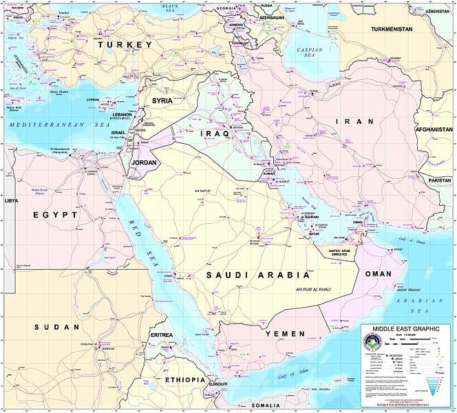
پرونده:Middle east graphic 2003.jpg

این پیش-پیش سِراق هدائن ِقایده: ۶۶۴ × ۶۰۰ پیکسل. دیگه کیفیتون: ۲۶۶ × ۲۴۰ پیکسل | ۵۳۲ × ۴۸۰ پیکسل | ۸۵۰ × ۷۶۸ پیکسل | ۱٬۱۳۴ × ۱٬۰۲۴ پیکسل | ۲٬۲۶۸ × ۲٬۰۴۸ پیکسل | ۲٬۹۷۳ × ۲٬۶۸۵ پیکسل.
اصلی پرونده (۲٬۹۷۳ × ۲٬۶۸۵ پـیـکـسهل, فـایـل گـأتـی: ۳٫۹۱ مگابایت, MIME مـونـد: image/jpeg)
فایل تاریخچه
تاریخ/زمونها سَر کلیک هاکنین تا اون گدِر ِنسخه ره هارشین.
| تاریخ/زمون | انگوسگتی | ابعاد | کارور | توضیح | |
|---|---|---|---|---|---|
| إسا | ۸ فوریه ۲۰۱۲، ساعت ۲۲:۳۰ |  | ۲٬۹۷۳ در ۲٬۶۸۵ (۳٫۹۱ مگابایت) | M0tty | Remove compression artefacts by a bilateral filtering. |
| ۱۴ ژوئیه ۲۰۰۶، ساعت ۲۱:۴۳ |  | ۲٬۹۷۳ در ۲٬۶۸۵ (۱٬۰۱۳ کیلوبایت) | Unquietwiki | ''Courtesy of the University of Texas Libraries, The University of Texas at Austin'' [http://www.lib.utexas.edu/maps/middle_east.html http://www.lib.utexas.edu/maps/middle_east.html] High-resolution political / railway / roadmap of the Middle East. |
پروندهی استفاده
این صفحه لینک هِدانه این فایل ره:
پروندهیِ گِردِ استفادهئون
این ویکیون هم این پرونده جه استفاده کانّه:
- کاربرد ar.wikipedia.org دله
- ويكيبيديا:قوالب/بذور
- ويكيبيديا:قوالب/بذور/جدول بذرة 1
- قالب:بذرة جغرافيا الشرق الأوسط
- بادية الشام
- محافظة العاصمة (البحرين)
- خليج عدن
- دزفول
- زاغروس
- مسجد سليمان
- زاينده
- مسرح أحداث الشرق الأوسط خلال الحرب العالمية الثانية
- الحويزة (مدينة)
- قائمة جزر الخليج العربي
- شرق المتوسط
- قائمة نزاعات الشرق الأوسط الحديثة
- مستخدم:Adnanzoom/مساعدات
- عبد الله بن سعيد
- قرار مجلس الأمن التابع للأمم المتحدة رقم 1381
- مستخدم:ASammour/بذرة-بوابة
- شرف الدين بن الحسن
- فخر الدين بن عدي
- صخر بن صخر بن مسافر
- قالب:بذرة أعلام الشرق الأوسط
- أبجر التاسع
- کاربرد arz.wikipedia.org دله
- کاربرد ba.wikipedia.org دله
- کاربرد be.wikipedia.org دله
- کاربرد bn.wikipedia.org دله
- کاربرد ca.wikipedia.org دله
- کاربرد ce.wikipedia.org دله
- کاربرد ckb.wikipedia.org دله
- کاربرد el.wikipedia.org دله
- کاربرد en.wikipedia.org دله
سراسری استفاده ره این پرونده جه سٮراق هاده.


