
پرونده:Pechora.jpg

این پیش-پیش سِراق هدائن ِقایده: ۴۶۳ × ۵۹۹ پیکسل. دیگه کیفیتون: ۱۸۵ × ۲۴۰ پیکسل | ۳۷۱ × ۴۸۰ پیکسل | ۵۹۳ × ۷۶۸ پیکسل | ۷۹۱ × ۱٬۰۲۴ پیکسل | ۱٬۷۰۰ × ۲٬۲۰۰ پیکسل.
اصلی پرونده (۱٬۷۰۰ × ۲٬۲۰۰ پـیـکـسهل, فـایـل گـأتـی: ۸۰۳ کیلوبایت, MIME مـونـد: image/jpeg)
|
|
این پرونده ویکیتلمبار دله دَره. ونه دلهی بنویشتهئون (مازرونی) ره اینجه سِراق دنه. |
گزارش
| توضیح |
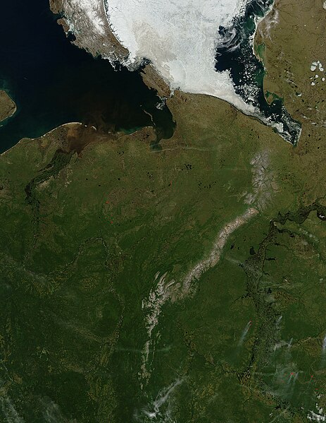
English: Pechora River
sattelite photo On July 3, 2004, sea ice still covered much of the Kara Sea in Northeastern Russia, near the western edge of Siberia, when the Moderate Resolution Imaging Spectroradiometer (MODIS) on NASA’s Aqua satellite captured this image. The southern tip of Novaya Zemlya Island curves out of the upper left corner of the image and is separated from Vaygach Island by Karskiye Vorota Strait. The narrow Yugorskiy Shar Strait, which separates Vaygach Island from mainland Russia, is clogged with sea ice. To the west, image left, the Pechora River is emptying brown, sediment-rich water into the Pechorskoye Sea. The water is probably loaded with mud as the far north thaws for the summer. In the lower right corner of the image, MODIS has detected a handful of fires, marked in red, which are sending light plumes of smoke to the southwest. |
| منبع | شه کار |
| سازنده | user:Svart |
اجازهنومه
| این پرونده در مالکیت عمومی قرار دارد چرا که توسط ناسا ایجاد شده است. سیاست حق تکثیر ناسا بیان میکند که «مواد ناسا با حق تکثیر محافظت نمیشوند، مگراینکه ذکر شده باشد». (Template:PD-USGov، صفحهٔ سیاست حق تکثیر ناسا یا سیاست جیپیال استفاده از تصاویر را ببینید.) | ||
 |
هشدارها:
|
فایل تاریخچه
تاریخ/زمونها سَر کلیک هاکنین تا اون گدِر ِنسخه ره هارشین.
| تاریخ/زمون | انگوسگتی | ابعاد | کارور | توضیح | |
|---|---|---|---|---|---|
| إسا | ۲۷ مارس ۲۰۰۶، ساعت ۲۱:۴۷ | | ۱٬۷۰۰ در ۲٬۲۰۰ (۸۰۳ کیلوبایت) | Svart~commonswiki | '''Pechora River''' sattelite photo On July 3, 2004, sea ice still covered much of the Kara Sea in Northeastern Russia, near the western edge of Siberia, when the Moderate Resolution Imaging Spectroradiometer (MODIS) on NASA’s Aqua satellite captured |
پروندهی استفاده
این صفحه لینک هِدانه این فایل ره:
پروندهیِ گِردِ استفادهئون
این ویکیون هم این پرونده جه استفاده کانّه:
- کاربرد af.wikipedia.org دله
- کاربرد ar.wikipedia.org دله
- کاربرد arz.wikipedia.org دله
- کاربرد ast.wikipedia.org دله
- کاربرد az.wikipedia.org دله
- کاربرد be.wikipedia.org دله
- کاربرد bg.wikipedia.org دله
- کاربرد bn.wikipedia.org دله
- کاربرد ca.wikipedia.org دله
- کاربرد ceb.wikipedia.org دله
- کاربرد ce.wikipedia.org دله
- کاربرد de.wikivoyage.org دله
- کاربرد diq.wikipedia.org دله
- کاربرد en.wikipedia.org دله
- کاربرد eo.wikipedia.org دله
- کاربرد es.wikipedia.org دله
- کاربرد eu.wikipedia.org دله
- کاربرد fi.wikipedia.org دله
- کاربرد fr.wikivoyage.org دله
- کاربرد ga.wikipedia.org دله
- کاربرد gl.wikipedia.org دله
- کاربرد he.wikipedia.org دله
- کاربرد hy.wikipedia.org دله
- کاربرد id.wikipedia.org دله
- کاربرد lmo.wikipedia.org دله
- کاربرد lv.wikipedia.org دله
- کاربرد mhr.wikipedia.org دله
- کاربرد mrj.wikipedia.org دله
- کاربرد myv.wikipedia.org دله
سراسری استفاده ره این پرونده جه سٮراق هاده.