
پرونده:St. Johns, Arizona (101310387).jpg

اصلی پرونده (۱٬۶۰۰ × ۱٬۲۰۰ پـیـکـسهل, فـایـل گـأتـی: ۶۱۰ کیلوبایت, MIME مـونـد: image/jpeg)
|
|
این پرونده ویکیتلمبار دله دَره. ونه دلهی بنویشتهئون (مازرونی) ره اینجه سِراق دنه. |
.jpg)
.jpg?uselang=mzn)
گزارش
| توضیح |
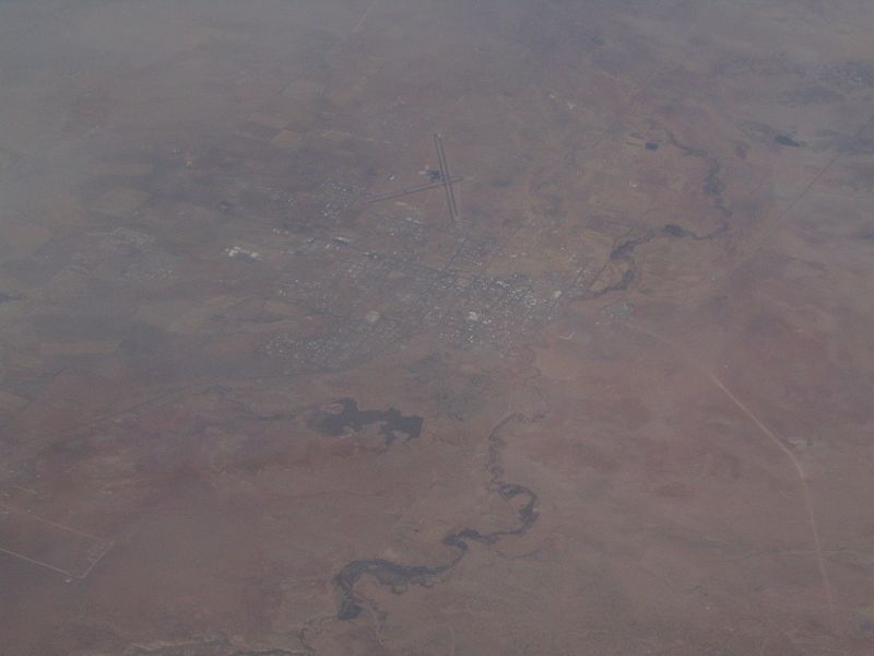
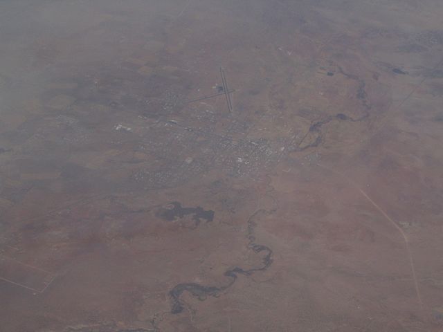
St. Johns is the only city in and the county seat of Apache County, Arizona, United States. It is located along U.S. Route 180, mostly west of where that highway intersects with U.S. Route 191. According to 2006 Census Bureau estimates, the population of the city was 3,538. St. Johns was first settled in 1873 by the Barth Brothers. They were bought out in 1879 by Ammon M. Tenney. St. Johns has been the county seat for almost all of the county's history. When the county was created on February 24, 1879, Snowflake was designated the county seat. After the first election in fall 1879, county government was set up in St. Johns, though it was moved again in 1880, to Springerville; in 1882 St. Johns again became the county seat, and it has remained so ever since. St. Johns is home to the Apache County Historical Society Museum and has four National Register of Historic Places: Isaacson Building, Lower Zuni River Archeological District, Lyman Lake Rock Art Site, and Rattlesnake Point Pueblo. St. Johns is near the Placerias Quarry, the site where dozens of Placerias fossils were discovered in 1930 by Charles Camp and Samuel Welles, of the University of California, Berkeley. St. Johns is along the shortest and most scenic route from Phoenix to Albuquerque, New Mexico. Within an hour's drive from St. John's are Apache-Sitgreaves National Forest, Petrified Forest National Park, the Painted Desert, and Lyman Lake State Park, as well as Indian reservations such as the Navajo Nation, Fort Apache Indian Reservation, San Carlos Apache Indian Reservation, and Zuni Indian Reservation. en.wikipedia.org/wiki/St._Johns,_Arizona en.wikipedia.org/wiki/Wikipedia:Text_of_Creative_Commons_... |
| تاریخ | |
| منبع | St. Johns, Arizona |
| سازنده | Ken Lund from Reno, Nevada, USA |
| مختصات دوربین | | محل قرارگیری این نگاره و سایر نگارهها در: نقشهٔ شهری باز |
|---|
.jpg¶ms=034.506910_N_-109.361858_E_globe:Earth_type:camera_source:Flickr_&language=mzn)
اجازهنومه
- شما اجازه دارنی:
- همباز بیّن وسّه – پروندهی ِکپی، توزیع و انتقال وسّه
- پشو بزوئن – پروندهی انطباق وسّه
- این شرایط جه:
- تخصیص – شما ونه اتجور بنویسین که اثر ِصاحاب ره نسبت هِدا بَوو، نا اینکه اتی بنویسین که مخاطبون فکر هاکنِن اون آدِم شمه بنویشته ره تأیید کانده.
- همباز هاکردن – اگه عکس سَر فقط اتکه تغییر هِدانی، بتونّی همون مجوز جه استفاده هاکنین.
| این نگاره در ابتدا توسط Ken Lund در https://flickr.com/photos/75683070@N00/101310387 به فلیکر ارسال شدهاست و در ۳ دسامبر ۲۰۱۵ توسط ربات FlickreviewR بازبینیشده و اینکه نگاره تحت مجوز cc-by-sa-2.0 منتشر شدهاست تأیید شد. |
فایل تاریخچه
تاریخ/زمونها سَر کلیک هاکنین تا اون گدِر ِنسخه ره هارشین.
| تاریخ/زمون | انگوسگتی | ابعاد | کارور | توضیح | |
|---|---|---|---|---|---|
| إسا | ۳ دسامبر ۲۰۱۵، ساعت ۲۱:۴۳ | | ۱٬۶۰۰ در ۱٬۲۰۰ (۶۱۰ کیلوبایت) | INeverCry | Transferred from Flickr via Flickr2Commons |
پروندهی استفاده
این صفحه لینک هِدانه این فایل ره:
پروندهیِ گِردِ استفادهئون
این ویکیون هم این پرونده جه استفاده کانّه:
- کاربرد ar.wikipedia.org دله
- کاربرد arz.wikipedia.org دله
- کاربرد bg.wikipedia.org دله
- کاربرد ca.wikipedia.org دله
- کاربرد ceb.wikipedia.org دله
- کاربرد ce.wikipedia.org دله
- کاربرد cy.wikipedia.org دله
- کاربرد es.wikipedia.org دله
- کاربرد eu.wikipedia.org دله
- کاربرد he.wikipedia.org دله
- کاربرد ht.wikipedia.org دله
- کاربرد hu.wikipedia.org دله
- کاربرد it.wikipedia.org دله
- کاربرد lld.wikipedia.org دله
- کاربرد no.wikipedia.org دله
- کاربرد pl.wikipedia.org دله
- کاربرد pt.wikipedia.org دله
- کاربرد ro.wikipedia.org دله
- کاربرد sr.wikipedia.org دله
- کاربرد tt.wikipedia.org دله
- کاربرد uz.wikipedia.org دله
- کاربرد vo.wikipedia.org دله
- کاربرد www.wikidata.org دله
.jpg)