
فریزلند
(فريزلند جه بموئه)
مختصات: ۰۰″ ۰۰′ ۷°شرقی ۰۰″ ۱۵′ ۵۳°شمالی / ۷غرب ۵۳٫۲۵جنوب
| فریزیا | |

| |
 نقشه نقشه
| |
| ملت | فریزیها |
| استقلال | ندارنه |
| گتی | ۱۳٬۴۸۲٫۷۳ کیلومترمربع (۵٬۲۰۵٫۷۱ مایلمربع) |
| جمعیت | ± 2,655,391 |
| جمعیت انبسی | ۱۹۷ /هر کیلومترمربع وسه (۵۱۰ /مایلمربع) |
| زوونون | فریزی زوونون (فریزکی, شمالی فریزی, ساترلند فریزی), جیر آلمانی (East Frisian, غربی جیر آلمانی, خرونینگنی), هلندی, آلمانی, دانمارکی |
| دین | پروتستان |
| منطقه زمانی • ساعت تابستانی |
CET (یوتیسی ۱:۰۰+) CEST (یوتیسی ۲:۰۰+) |
| دامنه | .frl |
| * Integrated parts of the هلند and آلمان respectively, but with varying degrees of autonomy for the فریزیها population. | |
فریزیا، فریسیا یا فریزلند[۱] اتا منطقه هسته که شمال دریا پَلی دره و ونه ناحیه هلند دله فریسلاند ِایالت دله دره و ونه اتی پچوک بخش هم آلمان دله دره. این منطقه مردم اتسری زوون جه گپ زنّه و وشون زوونها ره فریزی زوونون گانّه.
نوم[دچیین]
مناطق مختلف این منطقه ره مختلف نوم جه اشناسنّه:
- Frisland (دانمارکی)
- Friesland (هلندی, آلمانی و هلند غربی فریزی)
- Fraislaand (ساکسونی سفلای هلند)
- Freesland (شرقی فریزی)
- Fresklun (Fering North Frisian)
- Freeschlon (Goesharde North Frisian)
- Freesklöön (Halligen North Frisian)
- Friislon (Heligolandic North Frisian)
- Fräischlön (Karrharde North Frisian)
- Fraschlönj (Mooring North Frisian)
- Fresklun (Öömrang North Frisian)
- Fräislound (ساترلند فریسی)
- Friislön (Söl'ring North Frisian)
- Fryslân (فریسکی)
- Freesklön (Wiedingharde North Frisian)
When the فرانسوی occupied the Netherlands, the name for the Frisian department was Frise. In انگلیسی, both terms, Frisia and Friesland are used.
Divisions[دچیین]
Frisia is commonly divided into three sections:
- West Frisia in the Netherlands corresponds roughly to:
- the province of فریسلاند
- the province of خرونینگن (استان)
- the northern parts of the province of هلند شمالی, historical West Friesland
- East Frisia in نیدرزاکسن, Germany corresponds roughly to:
- East Frisia in a more narrow sense:
- East Frisia in a wider sense (East Frisian peninsula):
- the Friesland district
- ویلهمسهافن
- the Saterland municipality
- the Butjadingen peninsula, historical Rüstringen
- the Wurster Nordseeküste municipality, historical Land Wursten
- North Frisia in شلسویگ-هولشتاین, Germany corresponds roughly to:
| منطقه | جیربخش | ایالت | پرچم | گتی | جمعیت | جمعیت انبسی |
|---|---|---|---|---|---|---|
| شرقی | Narrow | آوریش | ۳٬۱۴۲ کیلومترمربع (۱٬۲۱۳ مایلمربع) | ۴۶۵٬۰۰۰ | ۱۴۸ /هر کیلومترمربع وسه (۳۸۰ /مایلمربع) | |
| امدن (نیدزاکسن) | ||||||
| لیر شهرستون | ||||||
| ویتماند | ||||||
| واید | روسترینگن | ۴۲۳٫۰۵ کیلومترمربع (۱۶۳٫۳۴ مایلمربع) | ۴۵٬۷۲۶ | ۱۰۸ /هر کیلومترمربع وسه (۲۸۰ /مایلمربع) | ||
| District of Friesland | ۷۱۴٫۹۱ کیلومترمربع (۲۷۶٫۰۳ مایلمربع) | ۱۷۲٬۸۲۱ | ۲۴۲ /هر کیلومترمربع وسه (۶۳۰ /مایلمربع) | |||
| ویلهمسهافن | ||||||
| Municipality of Saterland | ۱۲۳٫۶۲ کیلومترمربع (۴۷٫۷۳ مایلمربع) | ۱۳٬۱۸۷ | ۱۰۷ /هر کیلومترمربع وسه (۲۸۰ /مایلمربع) | |||
| Municipality of Wüster Nordseeküste (ورستن) | ۱۸۲٫۰۸ کیلومترمربع (۷۰٫۳۰ مایلمربع) | ۱۶٬۷۹۹ | ۹۲ /هر کیلومترمربع وسه (۲۴۰ /مایلمربع) | |||
| شمالی فریزلند | هلیگولند | ۱٫۷ کیلومترمربع (۰٫۶۶ مایلمربع) | ۱٬۳۵۶ | ۷۹۸ /هر کیلومترمربع وسه (۲٬۰۷۰ /مایلمربع) | ||
| نوردفرایسلند | ۲٬۰۴۷ کیلومترمربع (۷۹۰ مایلمربع) | ۱۶۲٬۲۰۳ | ۷۹ /هر کیلومترمربع وسه (۲۰۰ /مایلمربع) | |||
| غربی فریزلند | فریسلاند | ۳٬۳۴۹ کیلومترمربع (۱٬۲۹۳ مایلمربع) | ۶۴۶٬۳۰۵ | ۱۹۳ /هر کیلومترمربع وسه (۵۰۰ /مایلمربع) | ||
| خرونینگن (استان) (Ommelanden) | ۲٬۳۲۵ کیلومترمربع (۸۹۸ مایلمربع) | ۵۸۲٬۶۴۰ | ۲۵۱ /هر کیلومترمربع وسه (۶۵۰ /مایلمربع) | |||
| غربی فریزلند منطقه | ۱٬۱۷۴٫۳۷ کیلومترمربع (۴۵۳٫۴۳ مایلمربع) | ۵۴۹٬۳۵۴ | ۴۶۸ /هر کیلومترمربع وسه (۱٬۲۱۰ /مایلمربع) | |||
نقشه[دچیین]
-
 Geographic region of Frisia
 -
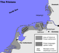 Frisian historical settlement areas, showing areas where a Frisian language is spoken today
 -
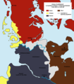 Frisian colonisation of the South West Coast of Jutland during the Viking Age (yellow)
 -
 فريزون پادشائي
 -


پانویس[دچیین]
- ↑ Grattan, Thomas Colley (1831). "The history of the Netherlands".
{{cite journal}}: Cite journal requires|journal=(help)